Unified Charts UK-NC
Stock code: UC-UK-NC
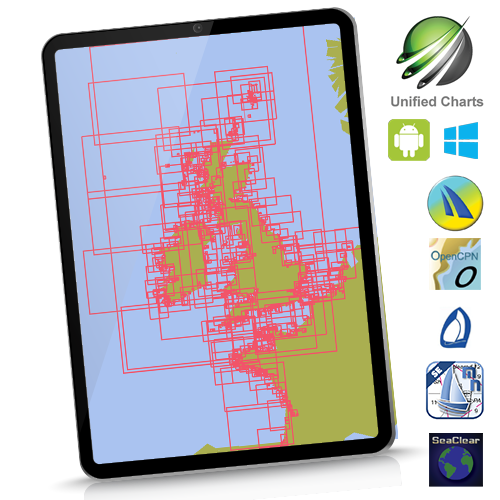
UK and Near Continent. Instant download for Windows machines. This 2026 edition contains over 1100 charts.
![]()
See hi-res samples, explore coverage. Click here
Coverage: UK/Ireland/Channel and Atlantic France/ Belgium and Netherlands coasts. 100% at all scales available. French coverage at all available scales using beautiful SHOM French raster charts.
For the avoidance of doubt: Our Netherlands coverage in this and any other product is shown below:
![]()
No freshwater inland coverage. Fine for coastal passage making.
Unified charts are compatible with nominated WINDOWS programs, not Mac, Linux, etc. The downloadable .iso image versions are licensed for ONE Windows machine, with ONE Windows backup allowed. Those requiring multiple Windows use, please buy the secure USB version.
Matching chartsets are also bundled or downloadable for Marine Navigator Android app or qtVlm app, with 2 mobile device activations allowed... In addition to the standard Windows useage.
Virtual DVD image (.iso) supplied by download. Easy activation process. Cheaper and faster than the USB.
All Unified Chart versions come with a free initial update, including download versions.
So, Unified Charts will work with standard WINDOWS versions of the following:
qtVlm SeaClear OpenCPN Polar View Expedition qtVlm
Plus Marine Navigator on Android (and qtVlm on Android and iOS)