
Your guide to UK harbours, with guides and navigation information
Welcome aboard visitMyHarbour
Your go-to online resource for sailors, cruisers, and anyone who loves life on the water.
We provide detailed harbour guides, seamless digital charts, and practical navigation tools designed to make your time on the water safer and more enjoyable.
Whether you’re planning your next trip, looking for a new marina to explore, or just brushing up on navigation, we’ve got you covered. visitMyHarbour brings together the essential information you need – all in one place.
We’re here to help you spend less time searching – and more time sailing.
Research possible destinations...
and stopping places, UK and Ireland... Harbours, marinas, creeks and inlets. Each location has full sailing directions, charts and photo galleries. All mooring options are covered, including: Prices, local facilities, provisioning, launching places, pubs and dining. Impartial and original information... free to use
Plan your next passage...
having researched possible stops and destinations, planning can now be started. Dates, tides and currents, fuel stops, contacts. All this information (inc. a unique planning tool) are here for members... Now using our "For Navigation" charts (below), prepare possible routes and waypoints in the comfort of your home.
Navigate "Real-Time" at sea..
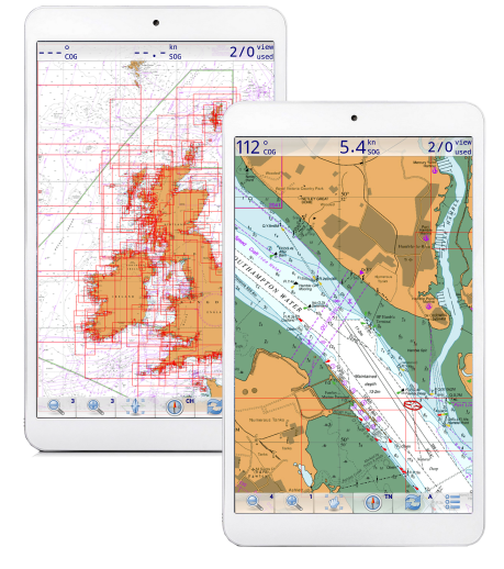
using our "buy and keep" chart packs (UK and international) running on various selected GPS navigation apps on your tablet, phone or laptop. Follow your planned routes. Adjust as required on the move. Supported programs include navigation, AIS, simulation and even weather/tide routing. YOU choose the program. inc OpenCPN
Your practical guide to harbours and marinas
Each harbour comes with full sailing directions, free charts, and photo galleries. You’ll find all mooring options covered – complete with prices, local facilities, provisioning spots, launching places, pubs, and dining recommendations.
Plus, stay prepared with 7-day weather forecasts and 2025 tide tables.
⚓ Logged-in visitors can share comments, updates, and local knowledge to help fellow sailors.
Our Harbours
Plan:
Gather the navigational info needed for passage planning.
"UK law requires every skipper/navigator to prepare a suitable passage plan prior to putting to sea. From start to completion (dock to dock), the voyage of each vessel must be described. This must include leaving the mooring and harbour area (pilotage), the main part of the journey (passage plan) and the approach and entrance/docking at the destination port (pilotage). These events are required to be documented for all vessels whether a small cruising yacht sailed by a leisure sailor, or a massive commercial freight carrier. SOLAS (International Convention for the safety of life at sea) requires a passage plan to be made even if it is only for a short leisure sail. And it needs to be written down. Failure to comply can lead to errors and navigational accidents. Even the use of passage planning software requires the plan to be written down prior to the proposed sea passage."
Membership
And THIS is where full membership of VisitMyHarbour really pays off. All the info you will need to prepare a proper passage plan is here for UK/Ireland. On this site or on the VMH-Lite site. A one stop shop to gather all the planning bits needed in advance.
Prepare your written passage plans using the vast collection of tidal and chart info at your disposal in the members area, combined with our harbour coverage in the free part of the sites.... Use the harbour coverage to prepare your written pilotage plans, draw sketch charts, note buoyage and light signatures. Using our unique VisiCharts overlay, you could draw your coming sea passage on the latest charts using standard Google Earth tools, And make notes about tidal gateways and timings. Lat/Lons can be extracted. All in all, so much planning can be done in the comfort of your home in front of a big screen.
Enjoy what you see on this website ? Join our other 8609 paid members (Sept 2024), including some very well known sailing "names".. A one off payment of £25 gets you ongoing membership of VMH Classic (this site). No more to pay. Access a whole trove of online research material, charts, plus stunning seamless zoomable 2024 Satellite/Chart image overlays. Download our own Harbour coverage as PDFs for offline use.
Navigate
 Made your plans ? Prepare routes in one of our GPS chartplotting systems...
Beautiful raster charts. A perfect foil for the vector charts in your marine chartplotter. Buy and keep (download or USB), NO SUBSCRIPTION. We concentrate on making charts available for existing GPS navigation softwares... running on phones, tablets and laptops you probably already have.
Our Android charts that run in "Marine Navigator" app are the best selling product we've EVER made from £13.60 for whole UK and Ireland coverage. 2025 charts now available.