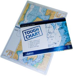
What were Tough Charts?
Admiralty Tough Charts were waterproof, spiral-bound charts developed with the Royal Yachting Association. They were designed specifically for use on open or wet boats, where standard paper charts would quickly become damaged.
Tough Charts were A3 in size, easy to handle, and built to withstand spray, rough handling, and constant use.
They were especially popular with RIB and powerboat users, but were equally useful on small yachts where durability and quick reference were important.
Availability Notice (2026)
Admiralty Tough Charts were withdrawn from production some years ago and are now discontinued. Any remaining stock may only be available through second-hand sellers or specialist chart retailers. Always check availability before relying on them for navigation.
What replaced Tough Charts?
They haven’t been replaced by a new paper product – they’ve been replaced by technology.
In today’s boating world, the role once filled by Tough Charts has largely been taken over by electronic navigation. Chartplotters and mobile devices running marine navigation apps now provide waterproof, backlit, GPS-positioned charts that are constantly updated and easy to use at speed.
For many powerboat and RIB users, a tablet in a rugged waterproof case has become the modern equivalent of a Tough Chart.
Paper charts are still carried for backup and planning, but digital navigation has become the primary tool, making Tough Charts less necessary than they once were.
What did a Tough Chart contain?
Charts numbered SC5901 to SC5911 typically included:
Around 20 main charts covering a specific coastal area
Harbour and approach plans at larger scales
Enlarged versions of standard Admiralty charts for easier reading at speed
Charts numbered SC5912 to SC5914 focused on:
Rivers and harbour areas within a region
A variety of scales suited to confined waters
Together, they provided full regional coverage in a format that was exceptionally tough and practical.
Why were they so popular?
Tough Charts were virtually the only charts that could be:
Used in heavy spray
Hand-held at speed
Folded, dropped, and soaked without damage
They were ideal for “eyeball navigation” in fast boats and demanding conditions, where durability mattered as much as accuracy.
⚓ Admiralty Tough Charts were a unique and highly respected product due to their extreme durability, ease of use in open boats and design for real-world marine conditions.
Although no longer produced, they remain fondly remembered and are still valued by boaters who manage to find copies in circulation today.
This article was first published in 30 March 2010