 This site is an online pilotage
guide, here to provide timely and detailed information about the
various ports and harbours, estuaries, rivers and inlets around the
coasts of the UK and Ireland.
This site is an online pilotage
guide, here to provide timely and detailed information about the
various ports and harbours, estuaries, rivers and inlets around the
coasts of the UK and Ireland.
Don't be confused about what we do on this site: Explain to me NOW
 Harbours: Each
harbour (NOT JUST marinas) has full sailing directions,
free charts , and photo galleries. All
mooring options are covered, including: prices,
local facilities, provisioning, launching places, pubs and dining.
Plus 7 day weather and tide times. Interactivity Logged in visitors
can leave comments and information.
Harbours: Each
harbour (NOT JUST marinas) has full sailing directions,
free charts , and photo galleries. All
mooring options are covered, including: prices,
local facilities, provisioning, launching places, pubs and dining.
Plus 7 day weather and tide times. Interactivity Logged in visitors
can leave comments and information.
Access from the menu on the left, Click here to browse
through all harbours Or: Access them via
Google
Earth if you have it installed. Harbours will appear as clickable markers
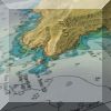 Online Charts: Enjoy what you see
on this website ? Join us ! A one
off payment of £25 gets you ongoing membership.
No more to pay. Access 1667 "Full Screen" charts
online, on PC, Mac or iPad. Use for planning and research. UK,
Ireland, Spain, Portugal, Netherlands, Belgium, W.Med, Atlantic,
Caribbean, Brazil etc.
Online Charts: Enjoy what you see
on this website ? Join us ! A one
off payment of £25 gets you ongoing membership.
No more to pay. Access 1667 "Full Screen" charts
online, on PC, Mac or iPad. Use for planning and research. UK,
Ireland, Spain, Portugal, Netherlands, Belgium, W.Med, Atlantic,
Caribbean, Brazil etc.
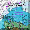
Lay UK/Irish charts over Google earth satellite imagery with variable transparency, 3D, "head up" view. Really see how things are ! Look at what you get in the "Members Only" area...Click HERE
 "Charts for SeaClear UK/IRL"at £29.50
is without a doubt the cheapest way for you to get 800+charts plus
tried and tested chart plotter
software (AIS and GPS compatible) . .. all in one
easy to use package that will turn multiple PCs/
laptops (and also Android tablets) into a real time chartplotters.
2015 edition now
available with charts dated 1st Jan 2015
and 2015 tide tables built in.
International areas inc. France, Netherlands and Belgium & Spain and Portugal
are available on USB dongle ONLY, see HERE
"Charts for SeaClear UK/IRL"at £29.50
is without a doubt the cheapest way for you to get 800+charts plus
tried and tested chart plotter
software (AIS and GPS compatible) . .. all in one
easy to use package that will turn multiple PCs/
laptops (and also Android tablets) into a real time chartplotters.
2015 edition now
available with charts dated 1st Jan 2015
and 2015 tide tables built in.
International areas inc. France, Netherlands and Belgium & Spain and Portugal
are available on USB dongle ONLY, see HERE
.
.
 French
charts are coming to all VisitMyHarbour
"For Nav" products. Available NOW for OpenCPN and Polar Navy software
300 DPI French Channel charts UK/IRL/BE/NL/ES/P and Channel FR charts now
availabl e on USB
from £39.50 : Click Here
French
charts are coming to all VisitMyHarbour
"For Nav" products. Available NOW for OpenCPN and Polar Navy software
300 DPI French Channel charts UK/IRL/BE/NL/ES/P and Channel FR charts now
availabl e on USB
from £39.50 : Click Here
French raster charts NOW available for SeaClear
and Android Click Here
 NEW & FREE
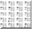
Tide Times: HW & LW. For the first time ever on the
web... Proper monthly tide tables, NOT just the next 7 days predictions .
Daily tide times, month by month all of 2016,
400 UK & Ireland locations. Useful for any coastal or
waterborne activity, and prepared using licensed data. Yachtsmen
and Boaters no more working out secondary port times... just look
them up here. Browse your area for long range tide tables:
South of EnglandEast England ScotlandWest of England, Wales and IoM IrelandChannel Isles
 Android chart plotter: Android tablets
with the RIGHT app can make a
great stand alone chart plotting system.. self contained with GPS,
quick starting, full navigation facilities. We've worked
with Ronald Koenig, the developer of the cracking "Marine
Navigator" Android app. Now Android
charts are bundled with our best selling "Charts for
SeaClear" DVDs for free. Up to 4 Android activations
allowed . App costs about £6 from Play
Store. NEW 2015
edition available
as Android only download £7.99
members/£14.99 non members
Android chart plotter: Android tablets
with the RIGHT app can make a
great stand alone chart plotting system.. self contained with GPS,
quick starting, full navigation facilities. We've worked
with Ronald Koenig, the developer of the cracking "Marine
Navigator" Android app. Now Android
charts are bundled with our best selling "Charts for
SeaClear" DVDs for free. Up to 4 Android activations
allowed . App costs about £6 from Play
Store. NEW 2015
edition available
as Android only download £7.99
members/£14.99 non members
 Marine Business
Directory: Our Directory lists almost 4000 marine
businesses, search by area, harbour, category, or any mixture of
these. Access from the individual harbour pages or browse all
The Business
Directory
Marine Business
Directory: Our Directory lists almost 4000 marine
businesses, search by area, harbour, category, or any mixture of
these. Access from the individual harbour pages or browse all
The Business
Directory
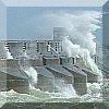
 Videos..."gems" in here inclucing a
very Non PC video of nautical mishaps, amateurs
and professionals making catastrophic mistakes. Click for Videos
Videos..."gems" in here inclucing a
very Non PC video of nautical mishaps, amateurs
and professionals making catastrophic mistakes. Click for Videos
Articles: A good selection of articles covering subjects ranging from anchoring to the weather. Long range tide tables, information about this site, products, plus lots more. Click for Articles
Finally, we are very approachable and easy to get hold of. We answer your emails and phone calls promptly...( 01983 293757 OR adminATvisitmyharbour.com) here's a selection of the type of enquiries we get and answer cheerfully.. You SAID.. we SAID