visitMyHarbour UK Pilotage and Harbour Information in a Box !
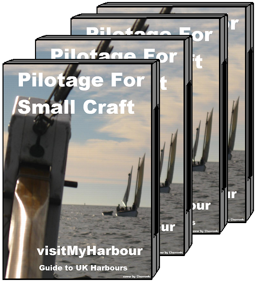
Pilotage in a box, no internet connection needed, read on:
Even with the advances in mobile Internet, there are going to be times when you want the information provided by visitmyharbour, but do not have a connection. Maybe you use a laptop on your boat, possibly for navigation... or maybe you keep your boat free of all electronics.
In either case our latest effort, could be of great use. We've rummaged our harbour coverage thoroughly and interwoven it with our area coverage. The result we present in the box above is perhaps the most comprehensive source of information you will get (in one place) concerning the coastlines of the UK.
All of our much used and highly praised harbour and area coverage is now available in easy to print PDFs , for you to keep. Now you can have all of our 2010 information on a disk, or loaded onto your computer.
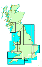
From Berwick-upon-Tweed in the North East, clockwise around to Tarbert in West Scotland. For full details of all the harbours we cover click here.
138 Harbours/Estuaries/Rivers and inlets are explored thoroughly. Pilotage directions, rules, hazards, tidal information. Berths, moorings, and marinas for visiting yachtsman with locations, contacts and prices. Shoreside facilities are explored.
650+ Pages absolutely packed with essential information for any small craft mariner making his way around the UK coastline. Print as required for use with your own paper charts, or use in digital form with your onboard laptop. No Internet connection needed.
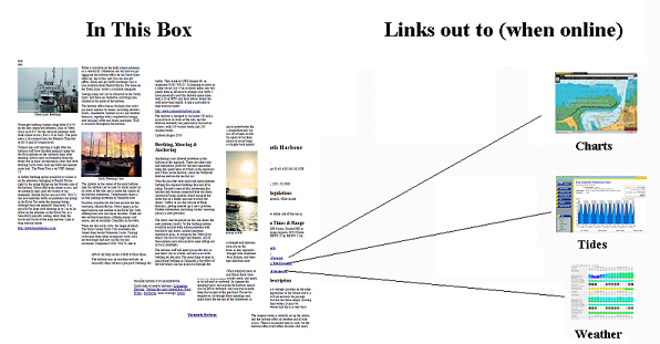
When used online these digital pilots link directly to: Free printable chartlets (300+) and NP tidal flow atlases, seven-day wind/weather forecasts, seven-day tidal predictions.
Separate added bonus: Big ships sailing directions, NGA Publications 141,142, 191, 192. 844 pages covering all the UK, Ireland and both sides of the English Channel.
What is in that good looking box ? One CD containing the following PDFs (use on PCs or Macs). Use direct from the CD or copy over to your onboard laptop. You can make copies providing it's for your own use only.
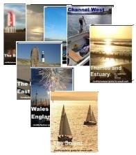 North East, 101 pages, 18 harbours
Thames and Medway, 69 pages, 12 harbours
English Channel East, 48 pages, 10 harbours
The Solent Area, 109 pages, 22 harbours
English Channel West, 113 pages, 25 harbours
Bristol Channel, 60 pages, 9 harbours
Wales and NW England, 70 pages, 12 harbours
Harbours of SW Scotland, 59 pages, 17 Harbours (No area coverage in this, as more harbours to cover. Area coverage is provided in the big ship coverage below)
Free Bonus:
"Official" Sailing Directions, provided by the National Geospatial Agency. Big ships sailing directions, NGA Publications 141,142, 191, 192. 844 pages covering all the UK, Ireland and both sides of the English Channel.
These are produced by the Americans, not the UKHO. We've rounded these up, and included them in this package. Although they are written for the big ship mariner, they are packed with useful information that has much relevance to the small craft sailor too. These downloads have the publication dates on them, and were obtained September 2010. PDFs, should work on all systems.
NGA Sailing Directions, Scotland
NGA Sailing Directions, Ireland and the West Coast of England
NGA Sailing Directions, English Channel
NGA Sailing Directions, North Sea
You can access the charts online, screenshot the chartlets you want, then save or print as required.
If you are using these PDFs at sea and have a mobile connection, you can access 7 day tidal and weather information, again direct from the links.
Suggested uses:
Non electronic boats:
- Print off the area/harbour coverage you need and use in conjunction with your own charts.
- Non members, when online at home, use the links to gather and print free harbour chartlets.
- Full members of VMH have 24/7 online access to ALL Home Waters (and many International) charts. Use screenshots/prints from these to accompany the pilotage.
- Use as an onboard digital pilot. Use in conjunction with your onboard chartplotter, or with chartlets you have previously saved from screenshots via VMH.
- Got mobile broadband ? Get weather, tides and loads of local info, direct from the links in the PDFs.
This unusual and interesting work is no longer
available as a separate work . We are
clearing our stocks as this pilotage work is now incorporated into
our VisiChart "For Navigation" chart package.
VisiCharts combine satellite imagery and charts into a
composite image, a GPS can be connected for positioning the boat.
Find out more about VisiCharts
NO LONGER AVAILABLE SOLD OUT
You purchased a "Charts for SeaClear UK/IRL"
DVD in late 2014 ?
Upgrade path from 2014 "Charts
for SeaClear UK/IRL" DVDs to the 2016 DVD... use
the link below to purchase the 2016 DVD for £20 if you
want to update and save £9.50 ...
Upgrade now to the 2016 DVD
And we will despatch the brand new 2016 "Registration Version"
UK/IRL DVD.
Have a good season in 2016 !
Best regards
VisitMyHarbour 36 High St, Cowes, PO31 7RS 01983 293757 Mon-Fri 11am-4pm
Terms and conditions:Terms and Conditions for use of this Website Terms and Conditions for use of Online Charts. Terms and Conditions for use of Tide Tables Privacy Policy Links Policy

Holding
HomePage
for v MH lite
Take a quick tour
Click HERE to start
This site uses cookies: Terms and Conditions for use of this Website