It's a small one off investment that just keeps giving...

Make a secure one off payment of
£25, get instant ongoing access.
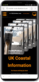
 For those who mainly use
phones or tablets and only want UK/Ireland info on the
move QUICKLY.. the VMH-Lite sitecould be a great
alternative.
For those who mainly use
phones or tablets and only want UK/Ireland info on the
move QUICKLY.. the VMH-Lite sitecould be a great
alternative.
For mainly desktop/laptop users who want full
online access to the classic VMH site, including 3D
VisiCharts and ongoing discounts on "For Nav"
products
- Joining up helps with our ongoing harbour coverage work... It's impartial, thorough and extensive. And is used a lot by those who move around the coasts of the UK and Ireland. If you use it, you should join.
- Our harbour coverage is available (to members only) as downloadable PDFs, always up to date. Research the places you may want to stop... and download our coverage to your tablet for offline use at sea.
- As an added incentive members get the physical and downloadable "For Nav" products we make at deep discounts (for example UK-Ireland Android Charts for Marine Navigator.. £9.99 members £15.95 non members). So with a "For Nav" VMH product, plus membership, you have all the tools to RESEARCH,PLAN & NAVIGATE your way around the UK coastlines..and much further too.
- Tide Tables.. Our online tide tables are designed so that you can get a whole month showing onscreen (of any of the 400+ locations covered). Will your chartplotter give you the tide times for September 12th at Wells-next-the-Sea ? Try HERE
- Tidal Streams.. The NP series of Tidal Strean atlases online for you to view. Some with added notes from old Admiralty Sailing Directions. eg: If you're thinking of sailing through the ferocious tidal streams of the Pentland Firth THISwill give you the best written description we've seen anywhere, scroll down past the the images for the textual description.
- Beautiful Charts...pushing back against the trend of horrid & ugly vector charts.. and even "seamless" electronic raster charts.. we've started displaying for members use, a huge and growing collection of the actual underlying hi res PAPER CHARTS. These "paper" charts are a perfect adjunct for those who use electronic plotters of any kind. Here's ONE REASON why and here's ANOTHER.
Note although we make products with SHOM French charts, they are not available for online viewing at present.
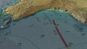
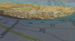
- Ramping up Google Earth as a nav & research tool. We were the first in 2012 with individual semi transparent overlay charts online. Now we've made it seamless !
Use the UK/Ireland streaming VisiCharts to really get a real feel for the scale of a creek, harbour or marina...before you go charging in. No other chart can do this. Passage Planning: If you get familiar with Google Earth, you can use our streaming VisiCharts to actually plan your passages from marina pontoon to sea and back into new harbours use built in Google Earth features to create a series of named or numbered waypoints, measure distances, get courses...
NEW.. Now for full members we are streaming all UK/Ireland, Belgium, Netherlands, Spain and Portugal charts in a form that drape themselves over Google Earth imagery... yes our own VisiCharts. Seamlessely.
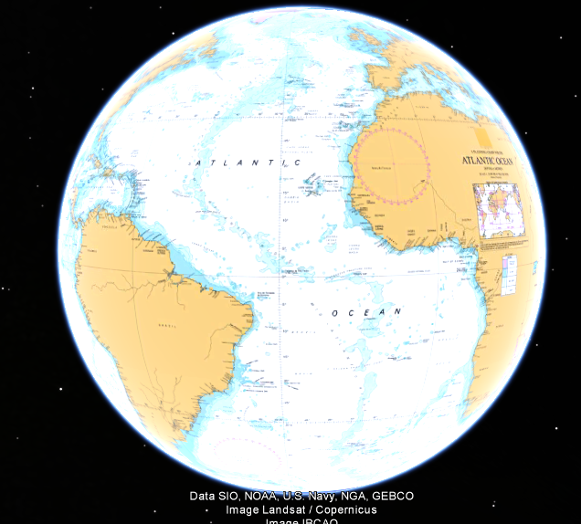
Start
with a globe covered in chart !
And zoom right in with tilt and variable transparency. UK/Ireland, Belgium, Netherlands, Spain and Portugal- Truly
visualise your destination and know what to expect, other
charts can't really help. The combination of satellite
imagery and overlaid chart is stunning.
- Quilted chart
layers make ordinary raster charts behave like vector
charts, but with far more detail. No need to keep changing charts,
the best scale pre-loaded chart for the
depth of view is presented automatically.
- Familiarity: Why use a strange, new, and difficult to
get used to program... VisiCharts harness the powerful geo-browser
engine in Google Earth, a tool you probably already use. Tools
already built into GE can handle simple routes and waypoints.
- For PCs and
Macs, these will not work on
mobile devices
- View your charts in conjunction with
satellite imagery, with variable transparency. You need
Google Earth already installed (Tip..find that transparency
slider)
- Tilt and rotate the view for 3D effects
Important note : This is stil an experimental service, we reserve the rights to change, modify or withdraw this at any time .
OK, let's see how members actually make full use of VMH in 2021.
Research: Online here on the VMH site. Find info about possible stopping places, moorings, prices, see photos, etc. Examine the possibilities using the VisiCharts online with satellite/chart overlays.
Plan: Gather the material you've researched, download the PDF coverage required. Make your notes and passage plans
Navigate : Using one of our "For Nav" chartpacks, often on an Android device. Routes, waypoints, etc can all be put in at the planning stage.. and easily tweaked for real time circumstances.
Gain online access to hundreds of zoomable
"paper" charts that will fill your screen with
chart. Make a secure one off payment of
£25, get instant ongoing access.
Who are we ?
VisitMyHarbour is an award-winning website, that
has been providing free UK pilotage information and charts to small
craft mariners for 6 years now. VisitMyHarbour has gone from
strength to strength, the free harbour coverage has doubled and you
will find us well indexed on Google. The website attracts between
1900 and 2700 unique visitors a day. VMH
has attracted nearly 6800+ paid members since 2010 (inc. some
very well known yachting names) and whose interests range from
hot air balooning to navigating in the Fastnet. Our service is
second to none, see some recent comments:
These online charts and tide tables are "Not for Navigation" purposes. (In common with charts and plans in pilot books and Almanacs) Membership is an online chart VIEWING service, it's not a chartplotting navigation system, you can't connect GPS input to it, plot AIS on it etc. See Legal notices and conditions . Memberships are for individuals only, not clubs or organisations.
UK and International Charts, Lists of what's available
PCs and Macs All full screen charts in members area,, all zoomable tide tables and streams, in full screen.
PCs and Macs with Google Earth installed: Seamless VisiCharts within members area in addition to above.
iPad/phone - Android devices: All full screen charts / tidal strreams, full screen Tide Tables for members only.. Not compatible with Google Earth VisiCharts. VMH lite is more suitable for quick tablet access. http://mobile.visitmyharbour.com
We will be displaying all the UK/Irish charts that are available. There are however a couple of exceptions where copyright issues prevent us from displaying the whole chart. A 12 month rolling replacement scheme will ensure UK charts are always up to date, urgent replacements will be made quarterly. International charts: Our growing collection is going online as fast as possible. It stands at 800 odd full sized "paper" charts online, with input from Spain, Portugal, Belgium, and the Netherlands amongst others. International charts are updated less frequently. No detailed French coverage online at present.
One off Membership fee:
This does not expire and there's no more to pay. How long does this last ? As long as this site is running, and the UKHO continue to license us (been running 15 years now and growing all the time). There will be no partial refunds in the future, and we cannot be held responsible for events outside of our control. We are a bona-fide business, and have achieved the Trading Standards buy with confidence logo.
Printing:
All Windows and Macs have built in capabilities for screen-shotting anything on your screen at the time. WARNING if you use these built in features to screen-shot and then print bits of chart images, the resulting printout IS NOT A NAVIGATION CHART. Printing of A4 chartlets from the material on this site is considered "Unauthorised Reproduction" by the UKHO. Under the well established doctrine of "Fair Use", you are legally allowed to make prints for "private study" amongst other things: MORE INFORMATION...CLICK
Copyright:
VisitMyHarbour are licensed to display these charts online. Most of the charts/UK tide tables displayed on this site are British Crown Copyright , and are displayed for your own personal use. You are strictly forbidden to use any of these images in your own websites, distribute copies of them, or e-mail copies of them to anyone. Links Policy

P.S.
When you join up with VisitMyHarbour.com, you are not enriching the coffers of some moneygrubbing PLC. You're not paying £7.50+ for some smeared 2 page black and white photocopy from an archived magazine. You are able to examine in the finest detail over £12,810's worth of up-to-date charts.
Paid up member or not, we endeavour to answer all your enquiries and help in any way we can. We truly do believe in the brotherhood of the sea, and aim to work in a spirit of co-operation. We are in the ongoing process of gathering and building up the best and most up to date pilotage information available for UK waters, and with your support we'll accomplish it.
We are also now making top selling "for navigation" chartplotter packages for your laptop, and for Android. Please support our work by joining up as a member.
It may also be fashionable to knock the UKHO in some circles, grumbling about taxpayers money etc. The fact is they provide the source information for all things nautical around our coasts, licence their copyright data, and stand on their own feet as a trading fund without taxpayers money. Long may it remain that way.
Best Regards,


Bryant and Thomson
PPS: If you have any enquiries or questions simply phone customer services. Likewise if you have any problems accessing your charts or are unhappy in any way in with your purchase simply Contact Us Now: Contact Us